£274.07
Add to Cart
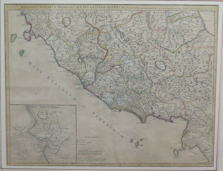
Engraving Antique paper Geographical Map Italy Central 1745 John Senex X9
Only 1 available
Details
Shipping: United Kingdom: free (more destinations)
Condition: Used
*The store has not been updated recently. You may want to contact the merchant to confirm the availability of the product.


OLD engraving1712--ANTIQUE PRINT1712 DESCRIPTION / DESCRIPTION Ancient map of central Italy engraved by Des Rosiers, prepared by Del'Isle and published by Dezauche, as successor to De l'Isle and Buache. Guillaume de l'Isle, appointed Royal Geographer in 1718, was the leading French cartographer of the early 18th century.Includes central Italy within the limits: north, Spoletium; south, Pompeii. Prospective mountainous orography. The Roman streets with their names are traced. The woods and marshy areas are distinct; aqueducts are indicated. The main towns are represented schematically in perspective. The toponymy is in Latin. Territorial divisions are in color. At the bottom left there is a map of Rome ("Urbis Septicollis"), with notes and a graphic scale in Roman steps. The longitudes refer to Ferro Island. The graphic scales are calculated in Roman miles and Greek stadia.Title: Regionum Italiae Mediarum Tabula GeographicaPublication date: 1745 Origin: Paris Conditions: excellentMeasures: 76 x 63 cm (including frame)Also present in the collections of Yale University, Beinecke Rare Book and Manuscript Library. --Fine historical map of central Italy with Tuscany, centered on Rome, in the south Pompeii, on top the island of Giglio and the town Orbetello. Lower left inset plan of ancient Rome. Engraved by Des Rosiers. Prepared by Del'Isle and published by Dezauche, as successors to De l'Isle & Buache. Guillaume de l'Isle, appointed Royal Geographer in 1718, was the leading French cartographer of the early 18th Century, and certainly among the most influential. Publication date: 1745Place of origin: Paris, FranceCondition: excellentDimensions: 28.74 x 24.80 in - (73 x 63 cm) frame included Do you want to see other ancient objects?Visit my eCRATER shop: belbello-antiquesVisit my eCRATER store: belbello-antiquesClick here! PAYMENT / PAYMENT --We accept the most common payment methods and cash on local pick up. SHIPPING / SHIPPING Insured and traceable shipping with delivery throughout Italy within 3-4 working days.International shipping is available.It is possible to pick it up by hand at our warehouse in Turin by making an appointment and at no additional cost.Each item is carefully packaged.We offer shipping discounts for multiple purchases. --Trackable and insured shipping.Delivery time: 5-7 working days.Local pick up available in Turin (Italy). RETURN / RETURN Return possible according to the law.--We accept returns. FURTHER INFORMATION / NOTE For viewing in person, any high resolution photographs or requests for clarification do not hesitate to contact us.--For any additional information or high resolution pictures feel free to contact us, we will be happy to answer your questions. Includes central Italy within the limits: north, Spoletium; south, Pompeii. Prospective mountainous orography. The Roman streets with their names are traced. The woods and marshy areas are distinct; aqueducts are indicated. The main towns are represented schematically in perspective. The toponymy is in Latin. Territorial divisions are in color. At the bottom left there is a map of Rome ("Urbis Septicollis"), with notes and a graphic scale in Roman steps. The longitudes refer to Ferro Island. The graphic scales are calculated in Roman miles and Greek stadia. Fine historical map of central Italy with Tuscany, centered on Rome, in the south Pompeii, on top the island of Giglio and the town Orbetello. Lower left inset plan of ancient Rome. Engraved by Des Rosiers. Prepared by Del'Isle and publIncludes central Italy within the limits: north, Spoletium; south, Pompeii. Prospective mountainous orography. The Roman streets with their names are traced. The woods and marshy areas are distinct; aqueducts are indicated. The main towns are represented schematically in perspective. The toponymy is in Latin. Territorial divisions are in color. At the bottom left there is a map of Rome ("Urbis Septicollis"), with notes and a graphic scale in Roman steps. The longitudes refer to Ferro Island. The graphic scales are calculated in Roman miles and Greek stadia. Fine historical map of central Italy with Tuscany, centered on Rome, in the south Pompeii, on top the island of Giglio and the town Orbetello. Lower left inset plan of ancient Rome. Engraved by Des Rosiers. Prepared by Del'Isle and publ


